26/08/2015

Raster Clipper and Raster Contour


For one who hardly ventures into raster GIS, I gave QGIS raster tools a try. I downloaded a natural earth file then panned over to Malaysia and zoomed-in farther. Raster data is heavy so it is wise to clip unnecessary area away and using the the Clipper, it worked fined then for the heck of it, I tried the Contour and even that worked out fine. I must say, QGIS is very user-friendly here but I must admit one has to use some common sense to choose the appropriate places to click and get results. I also found it easiest to increase the number of contour lines simply by reducing the number of intervals say shown below from 10m to 5m to 1m though it can get to be a bit jagged when the contour points are too far apart as shown by the 1m intervals.


15/04/2015

Training: QGIS training to MBSA, Shah Alam 24-25.3.2015


This represents the last QGIS training whilst I was in government service before I pension early this year. I must say the staff of MBSA were very enthusiatic about learning how to use QGIS and like many, were impressed that is not such a difficult software to use ...after some formal training to guide them across. And like always I told them, practice makes perfect and I do not expect them to be good at it until they use it daily for a month as most of them are even still new to the world of GIS. 

Asmaniza Adzi
QGIS mesra pengguna, menarik, senang dan mudah digunakan

Azliyana Abd Halaim
Mudah dugunakan apabila mendapat latihan yang chukup

Nurul Qalby Abdullah Sani
User-friendly, sangat mudah difahami dan mudah digunakan. Ianya satu perisian yang bagus dan menarik

Zuhaili Badianahan
QGIS merupakan perisian yang boleh baca semua persiaan seperti ArcGIS , MapInfo dan sangat berguna untuk perancang bandar

Shazana Mohd Noor
QGIS sesuai digunakan dan mudah. Perlukan lagi kkursusQGIS ini untuk menamahkan ilmu untuk penggunaan perisian ini.

Muhammad Nizam Md Yusof
Mudah dan cepat

Siti Azliza Ahmad
Mula-mula tak faham, se;epasa dah buat latihan dan diberi penegerangan QGIS ini mudah dan cepat dan sesuai digunakan dalam bidang perancnagan.

Syamrul Nizam
Sesuai digunakan , mudah difahami dan cepa

Abdul Aziz
Sangat mudah difahamai dan yang paling penting adalah ianya percuma.

Ahmad Nazmi
Perisian yang mudah digunakan dan difahamaioleh pengguna. Akan tetapu memerlukan kursus/latihan lanjutan untuk lebih mahir

Mahazir Jais
Software yang memdudahkan kerja GIS

Shahril Bashar
Mudah untuk digunakan

26/03/2015

I-PLAN and QGIS

An existing landuse plan using I-Plan qml planning colour template
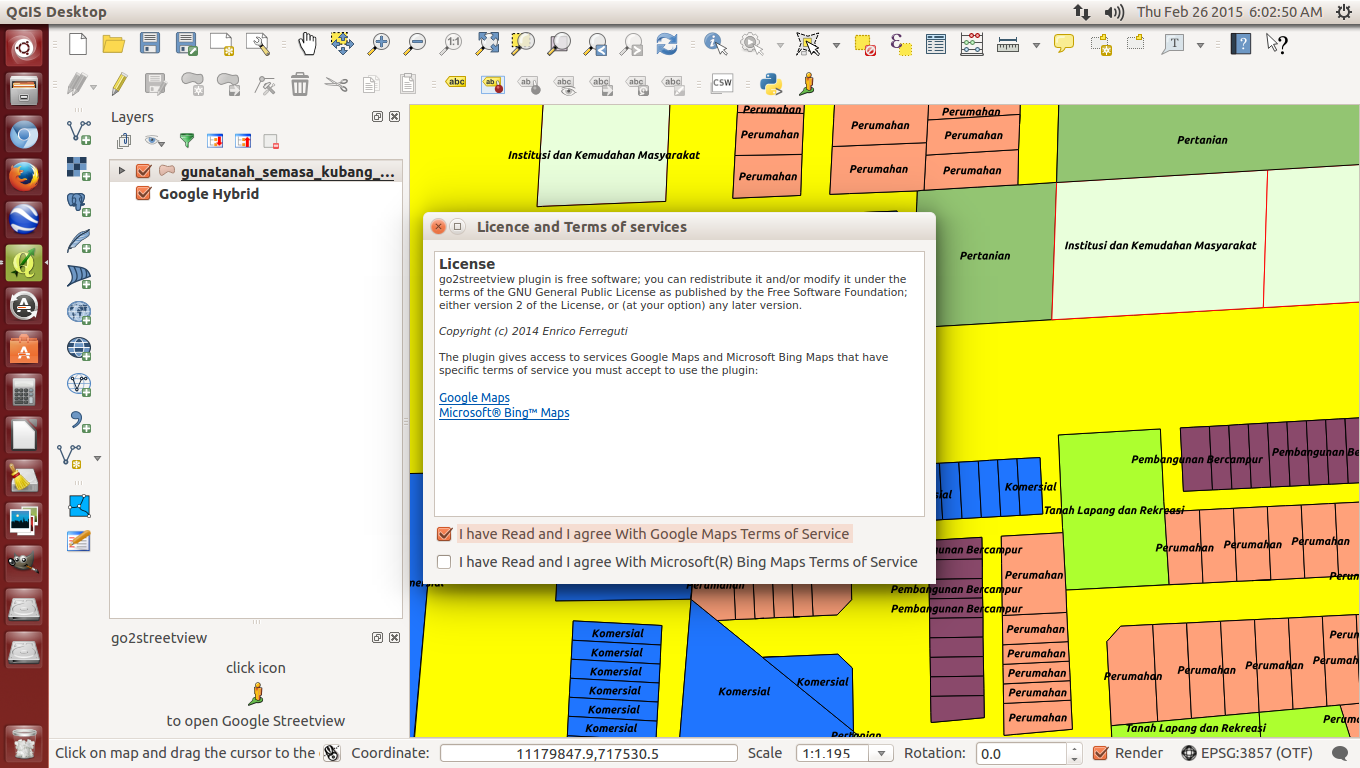
QGIS Ver. 2.8 shows  I-Plan existing landuse compatible with Google Hybrid
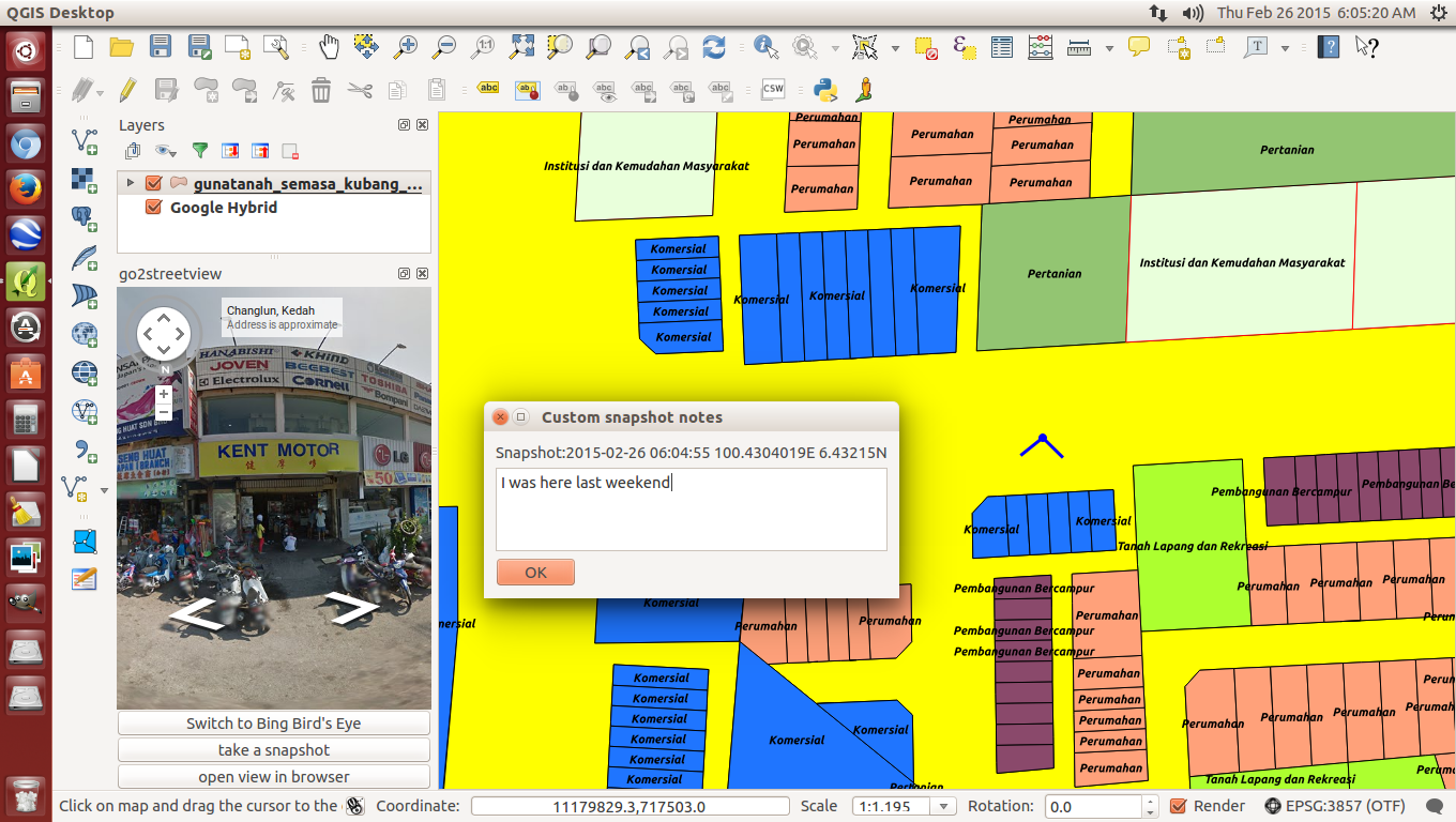
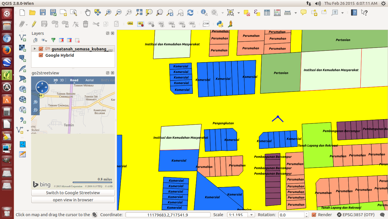
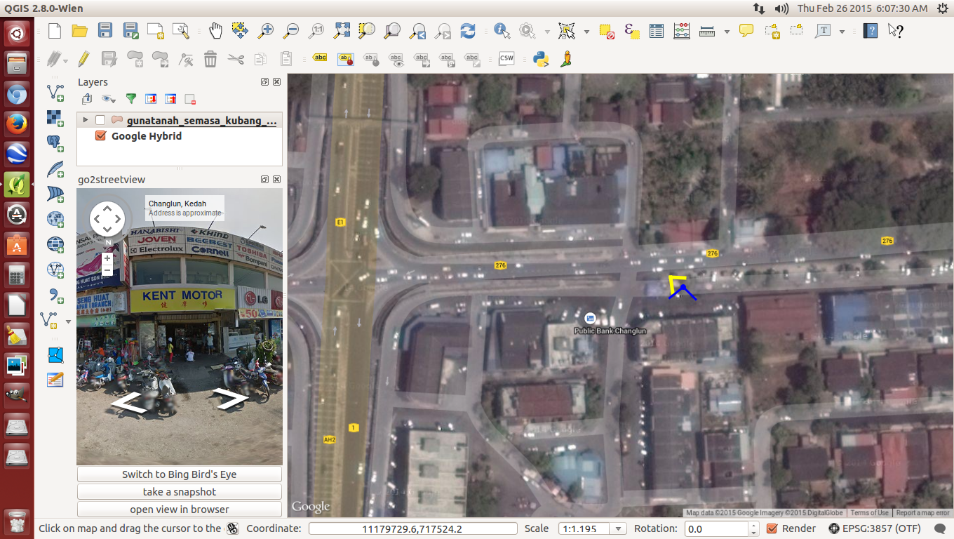
Go2streetview works well on top of the landuse map with Google Hybrid underneath

In a nutshell, the Federal Department of Town and Country Planning (JPBD), Peninsular Malaysia's  Integrated National Landuse Information System (I-Plan) began development in October 2013 and is scheduled to be completed by the end of 2015. This landuse information system utilizes an enterprise relational database management system (RDBMS) linked to a web geospatial aplication for easy and convenient access to all interested parties including public. It is built wholly using Open Source Software (OSS) including Quantum GIS (QGIS) at workstations (initially distributed to every State Planning Department and eventually proposed to be distributed to every local planning authority), Enterprise PostgreSQL-PostGIS for the RDBMS, OpenGeo Suite for the GIS application and Tomcat Apache for the web application whereby the operating system for both server and desktop computer is my favourite Ubuntu (Isn't that a coincidence?). Incidentally, the preference for OSS as against the use of proprietary software saved the total project cost by about RM6 million. The centralized system consists of 7 physical servers and 3 virtual servers incorporating Development, Production, Database, GIS and failover functions. The initial stage involves vertical linkages from all local planning authorities within Peninsular Malaysia to  all State Planning Departments and eventually to the centralized I-Plan system at Kuala Lumpur. In years to come, the system will be extended to horizontal linkages between the I-PLAN system and geo-spatial systems at key government agencies that want to share JPBD's landuse data via map services. The I-Plan project is a massive exercise to coordinate, standardize, collect, rectify topology errors, update landuse data and transform previous landuse maps from the Survey Department's state Cassini Soldner map projections to their Geocentric Datum of Malaysia (GDM2000) map projections. The I-Plan system covers 3 landuse category namely zoning, committed and existing landuse. Map update will be carried out bi-annually beginning 2015 on a district-sharing basis between JPBD departments at the federal and state level to help overcome technical manpower shortage at many local planning authorities mainly District Councils and ensure landuse data will not be obsolete but always up-to-date on a scheduled basis  and accurately recorded. Myself, being as I-Plan Project Manager will not see it complete as I have to call it a day and pension by the end of this month where at this point in time, who will replace me is a million dollar question.

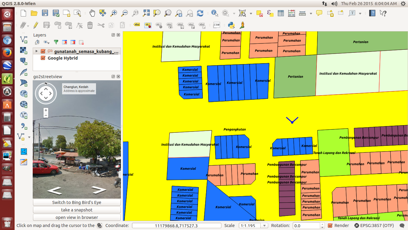
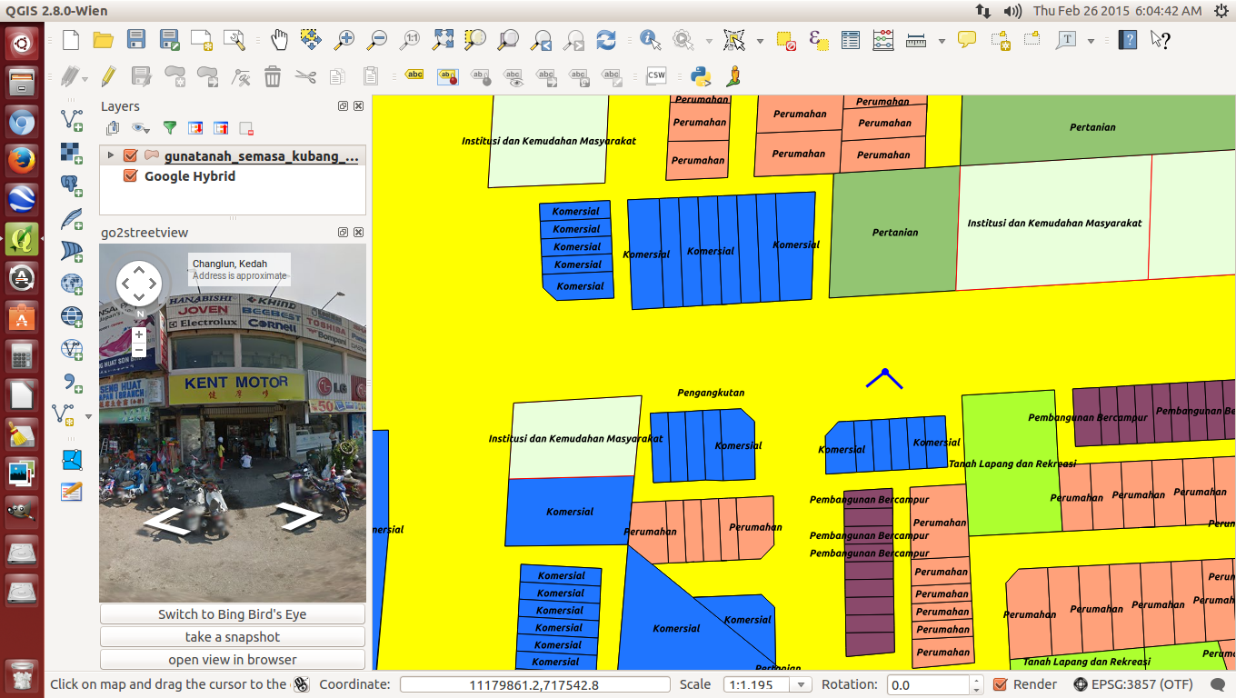
In the meantime,  using the Linux Ubuntu QGIS Ver 2.8 at my office desktop computer, I activated one of the existing landuse maps for a particular local planning authority. That GIS map had already been transformed to GDM2000 map projection. Next, I added the JPBD town planning .qml colour template (which we customized based on the second version of JPBD's GIS manual for development plans) to that map and everything worked out fine. This was followed by activating Google Hybrid. I was expecting QGIS to crash as in previous version because Google Hybrid had to be activated first but no, not this version. It worked out fined again though of course, I had to move the raster Google Hybrid below the vector landuse map. Finally, I activated the go2streetview plugin. At first, I was not expecting it to work as I had the Google Hybrid underneath the landuse map and expected it only to work in synergy being directly on top of Google Hybrid but no, it worked out fine again and on top of the landuse map. As I rotated the view angle, I could see what was around the spot I had chosen to view. OMG, this will surely be a great help to local planning authorities that can now do virtual site visits and save themselves, time, money while enjoying the comfort of their office/home. It makes cross inspection between what is on a GIS map and the site so easy. As a government servant, I wanted so much to make QGIS the principal GIS for the public sector and I believe I have succeeded here, well, give it one or two more years because I-PLAN is making it popular nationwide among local planning authorities, me, having shrewdly defacto-ed it at I-Plan workstations. I look back at when I got to first know QGIS in 2009 and now see the tremendous improvements that have come about especially over the past few years, I must take my hat off to the dedicated developers who made it possible as I am but a humble user.

26/02/2015

How to get help on QGIS fast when there's no one around to help?

Type key words to query
My query already asked and properly phased by someone
Checking info on "Affline Transformation"

I believe like so many of us, this is a common problem among first time QGIS users, that is, getting help on QGIS yet having no one reliable around who can help give advise and direction. Well, then do what I did when I first started to get to know QGIS... help is in actually in front of you if you are sitting in front of an internet computer. (Nowadays, this situation also covers smartphone users). I found that Google's search engine is the most reliable "friend" to guide me in this quest for knowledge. I also I found out from my many training class on QGIS that many people do not actually know how to use an internet search engine intelligently. The trick is actually to enter key words related to one's query but even if you don't even know what that is, type in the Google search engine box a proper question like "What is so and so?" Even the query type: What, When, Where, Who or How helps to further filter the query specifically and that helps to get better results. You can see in the first image, even I was too lazy to type a proper question but because it had key words, that helped a lot. In the second image, someone actually made my life easy and even asked my query as a proper question. Because 2 options were given, I went on further to click on other sites to get more information. Now, it's time for me to read on and see if I can get what I wanted. Wish me luck.

Go2streetview for convenient and lazy armchair monitoring

Of course, firstly, the appropriate plugin needs to be installed
Once activated, just close your eyes and tick the 2 boxes
Click on a particular road and a "north" street view appears on the left
Turn the North of the cardinal points to south for the other street view
Adding caption to snapshots is also possible
Bing browser also available if you prefer to
Site location less existing landuse map
Once in a while, I become a busybody and have a peep to see what's new under the Plugins section. WALLA! I noticed a Google's Map street view plugin is available. I don't know how long it existed but I decided to give it a try. As usual, that Go2 streetview plugin needs to be installed. Then, I activated Google Hybrid next decided to activate the existing landuse map, as in this case, for Kubang Pasu district in Kedah. After activating Go2streetview under the Menu bar, I clicked on an existing road because that's the way Google Streetview works where hopefully that road has been surveyed by Google's street view team (I went over to Mauritius and although that country is developed, sadly, the streets have not been surveyed by Google's Streetview team) and a License agreement box popped out. I tried just clicking the first box but the module didn't work so I guess they wanted me to click the second box too. OK!OK! Let's not be too fussy and so I did then immediately a panaromic view angle appeared, by default pointing northwards and the street view could be seen in the box on the left. To see the other views, I rotated the cardinal point knob. All this while, I was surprised that the view angle point could connect with the Google Hybrid map underneath the existing landuse map, I didn't expect that. Cool! Some extras include viewing under Bing browser, taking a snapshot and putting up some comments, if needed. I think this is an excellent tool for comparing and monitoring between Google's maps and a preferred map be it a zoning map or in my case, an existing landuse map. I checked the visibility of the Streetview module and it is so sharp, I am so embarassed to show where my house is because you can even see the cracked tarmac road in front of my gate. I can imagine it is a a great help should the weather rains or in some countries, snows or it's too cold to go outside and one wants to check an unfamiliar site. This tool will surely help cut down petrol bills which is also good for the environment too. Because of that, I got to hand it and take my hat off to the QGIS team that took time and effort to develop this plugin. Simple things mean a lot. It gets my 5***** rating.

22/02/2015

Ubuntu QGIS Ver. 2.8 Wien installed!


Today, just came back from Sunday's grocery, I noticed there was a QGIS update. This rarely happens so it caught my eye so upon download and installation, Walla! I get a Ubuntu QGIS Ver. 2.8. First thing I did was test it and it successfully opened a recent I-PLAN landuse map with an update .qml file that compliments I-PLAN's revised landuse colour code...and it works . Yeaaaah.